If you are planning a boat trip, beach day or crossing from Porto San Paolo to Tavolara, a generic Sardinia forecast is not enough. The good news is that the Tavolara area now has unusually useful live information: a weather station and webcam at Cala Tramontana on the island, a long-running meteorological station at Porto San Paolo, and official Sardinian marine forecasts from ARPAS. Used together, they provide a much clearer picture of wind, sky and sea conditions around the protected marine area.
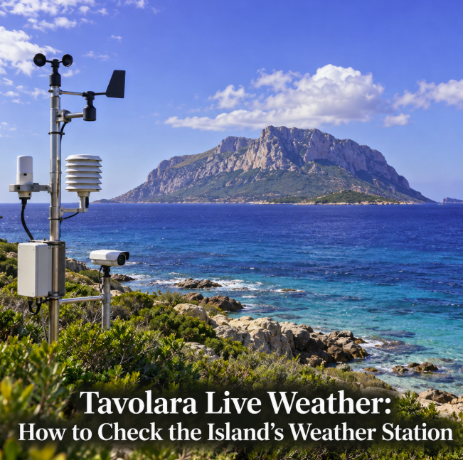
The most interesting development is on Tavolara itself. A new webcam installed at Spiaggia Tramontana became active in July 2026 and is paired with a Davis Vantage Pro 2 weather station. That gives travelers a way to look at actual conditions on the island rather than relying entirely on a forecast model.
The live station and webcam on Tavolara
The Tavolara webcam is installed at Spiaggia Tramontana, within the Tavolara–Punta Coda Cavallo Marine Protected Area. Current technical information identifies the camera location at roughly one metre above sea level and says it is paired with a Davis Vantage Pro 2 meteorological station.
The webcam is particularly useful because weather around Tavolara is visual. You can immediately see cloud cover, visibility and the appearance of the sea. A forecast icon saying “sunny” tells you much less about a boat excursion than a real image showing whether the water looks calm, hazy or wind-ruffled.
The camera service also provides timelapse views during different parts of the day. This helps reveal whether conditions are improving or deteriorating rather than offering only a single snapshot.
The station was not installed simply as a tourist novelty. Earlier documentation from the Tavolara marine protected area describes a project combining meteorological instruments with a 4K camera at Cala Tramontana, with images transmitted to the cloud for real-time viewing.
Porto San Paolo has another live weather station
Before boarding a boat, it is also useful to check conditions on the mainland side. The Meteorological Observatory of Porto San Paolo operates a Davis Vantage Vue station at about 51 metres above sea level, at approximately 40.845° N, 9.498° E.
Its live data page reports temperature, humidity, dew point, atmospheric pressure, wind speed and direction, wind gusts and rainfall. These observations are much more useful for a same-day decision than simply reading the maximum temperature in a weather app.
For Tavolara trips, wind deserves particular attention. A warm, sunny day can still produce an uncomfortable or unsuitable sea crossing when the wind strengthens. Checking both average wind and recent gusts gives more context than temperature alone.
Use webcams to see the sea
There are several visual viewpoints around the Tavolara area. In addition to the Cala Tramontana camera on the island, webcams around Porto San Paolo and Porto Taverna look toward Tavolara and Molara.
A Porto Taverna live camera, for example, provides an east-facing view across the beach toward Tavolara and Molara. This can be useful for judging visibility, cloud development and the general appearance of the water from the mainland coast.
Webcams should not be treated as formal marine-safety instruments. Perspective can make waves look smaller than they are, and a sheltered camera location may not represent exposed water. Their value is as a visual complement to measured wind data and official forecasts.
For official forecasts, check ARPAS
For forecast information rather than observations, ARPAS — Sardinia's regional environmental agency — is the key institutional source. Its meteorological service publishes general Sardinia forecasts, wind maps and sea-state forecasts for surrounding waters.
The ARPAS Meteo app, available in Italian and English, includes forecasts prepared and reviewed by professional meteorologists. Current features include detailed regional forecasts, marine conditions for seven sea areas, wave height and direction, wind animations, monitoring-network temperatures and national radar imagery updated every five to ten minutes.
This distinction is important: a private weather station tells you what is happening at its sensor, while ARPAS provides the broader meteorological and marine picture. Neither replaces the other.
What to check before a Tavolara boat trip
Start with the official forecast the evening before. Look at wind and sea state, not just the sun or rain symbol. On the morning of departure, check the Tavolara and Porto San Paolo live observations again.
A practical sequence is:
- Check the ARPAS marine and wind forecast for northeastern Sardinia.
- Look at the Tavolara webcam for actual visibility and sea appearance.
- Check live wind and gusts at the Porto San Paolo station.
- Compare nearby webcams around Porto Taverna if you want another visual angle.
- Confirm the departure with the boat operator, particularly when conditions are marginal.
The last step matters most. Excursion operators and ferry services make operational decisions based on conditions, vessel characteristics and safety. A traveler should not use a favorable webcam image to override a cancellation or warning from the crew.
Why different sources may disagree
It is normal for a weather app, a station at Porto San Paolo and conditions on Tavolara to show different values. They are not measuring exactly the same place.
Tavolara rises dramatically from the sea, and local topography can affect wind and cloud. Porto San Paolo is on the mainland and its station is elevated above sea level, while the Cala Tramontana equipment is close to the shoreline. A forecast model, meanwhile, represents an area rather than a thermometer at one exact point.
Even wind readings require context. An instantaneous gust is not the same as a ten-minute average, and a station sheltered from one direction can record conditions differently from an exposed stretch of water.
Live data or forecast: which matters more?
For deciding what clothes to wear at that moment, live observations are extremely useful. For deciding whether tomorrow's boat trip is likely to operate, the forecast matters more.
For marine activities, the strongest approach is to combine both. Forecasts tell you what meteorologists expect to happen; stations and webcams tell you what is happening now.
This is particularly useful in September and other shoulder-season periods, when a beautiful morning can coexist with a wind change expected later in the day.
A better way to check Tavolara weather
Searching simply for “Tavolara weather” often returns automated forecasts generated for coordinates near the island. Those can be convenient, but travelers now have better tools available.
The Cala Tramontana webcam and paired weather station provide direct local context, Porto San Paolo offers detailed live observations from the departure side, and ARPAS supplies the official regional wind and marine forecast. Together, those sources are far more informative than one temperature icon.
If you are heading to Tavolara for swimming, hiking or a boat excursion, check them shortly before leaving — and always give the final word on navigation conditions to the professional operator taking you across the water.