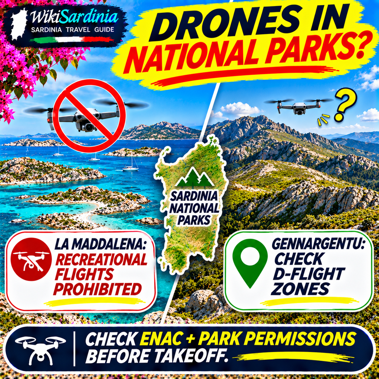
Do not launch a drone in a Sardinian national park without checking the official D-Flight map and the protected area's rules first. At La Maddalena National Park, ordinary recreational drone flights are prohibited under the park's published rules. The Gennargentu situation is more complicated: the proposed Golfo di Orosei–Gennargentu National Park has a distinctive legal and administrative history, and you cannot assume that every mountain trail has the same aviation restriction. In either area, a drone weighing less than 250 g is not automatically exempt from geographic no-fly zones.
Can tourists fly drones in La Maddalena National Park?
For ordinary holiday filming, treat the answer as no. The Parco Nazionale dell'Arcipelago di La Maddalena explicitly states on its filming-permission page that drone overflight is prohibited throughout the park. Its published June 2024 notice also recalls restrictions on flights, including remotely piloted aircraft, below 300 metres above sea level from January 1 through October 30, with limited exceptions and authorizations for specified activities. Do not interpret that seasonal wording as an automatic green light for recreational drone flights on October 31: the park's broader notice and the applicable D-Flight restrictions still need checking. La Maddalena Park — drone restriction notice; La Maddalena Park — filming authorizations.
Does the restriction include Spargi, Budelli, Caprera and the surrounding sea?
Do not assume that taking off from a boat, an uninhabited island or outside a beach avoids the park rules. The protected archipelago includes islands and marine areas, and restrictions are determined by the actual protected-area and aviation-zone boundaries. Check the exact location and intended flight path on D-Flight, as well as the park's rules. A drone launched outside a restricted area can still enter prohibited airspace. The fact that a drone is technically capable of taking off from a yacht or small boat does not establish legal permission.
Can you request permission to fly at La Maddalena?
The park identifies limited potentially authorizable purposes, including scientific or documentary filming, technical monitoring, institutional or public-interest video, environmental management and photogrammetric surveys. Its filming page asks applicants to submit a request describing the proposed activity and says the park will decide whether authorization can be issued under its rules. Contact the park in advance at protocollo@lamaddalenapark.it or consult the official contact instructions. Some activities in the relevant Natura 2000 protected area may additionally require a VINCA environmental-impact assessment procedure. Submitting an application is not permission to fly; wait for written authorization and satisfy any aviation requirements as well. Official application information.
What about Gennargentu National Park?
Do not treat the Gennargentu mountains as one automatically permitted or automatically prohibited drone zone. The Golfo di Orosei–Gennargentu National Park was formally established by decree in 1998 but has not become operational in the usual way, with implementation tied to later agreements and administrative arrangements. This is distinct from La Maddalena's functioning park authority and explicit drone guidance. Gennargentu and the surrounding area nevertheless include environmentally protected sites, and specific geographic flight restrictions may apply. Before flying near Punta La Marmora, Bruncu Spina, the Supramonte or the Gulf of Orosei, check the precise coordinates on the official D-Flight map and verify any additional local conservation or access conditions. Never infer permission solely from the park's administrative status.
Why is D-Flight essential?
D-Flight is the official Italian platform for checking geographical zones affecting drone operations. ENAC, Italy's civil aviation authority, requires operators to consult the map before each flight. Zones may exist for airport safety, security or environmental protection. In its February 2026 clarification, ENAC states that park-related aviation prohibitions are enforceable as such where the restriction has been approved by ENAC and published on D-Flight. ENAC also notes that some mapped park-zone boundaries are being revised to better match actual protected-area boundaries. Therefore, check the map for your exact launch location and intended flight area, not just a general park name. ENAC — UAS geographic zones and protected areas, updated February 2026.
Does a DJI geofencing map prove the flight is legal?
No. A drone manufacturer's app may offer useful technical warnings, but it does not replace the official Italian aeronautical map. A drone that allows its motors to start is not necessarily authorized to fly. Equally, the absence of a manufacturer's warning does not mean a protected-area restriction is absent. Check D-Flight, the local protected-area rules, the weather and the general operating requirements yourself.
Are sub-250 g drones such as DJI Mini models exempt?
No exemption from protected airspace restrictions follows merely from being under 250 g. Lower-weight drones may qualify for different requirements within the EU Open category, including some differences in pilot training and operating near people. However, geographic no-fly zones apply regardless of drone size. A camera-equipped drone may also require operator registration, and Italy imposes insurance requirements on UAS operators. Review the current ENAC and EASA rules for your particular aircraft before traveling. EASA — flying within geographical zones; ENAC — operator obligations.
What paperwork does an American tourist need?
US visitors must comply with the EU/Italian framework rather than assuming FAA recreational registration is sufficient. Depending on the drone and operation, requirements include an appropriate EU-recognized operator registration, identification marking, adequate insurance and any necessary remote-pilot competency evidence. Operators registered in another EASA member state generally should not create a duplicate operator registration in Italy. For visitors coming from outside the EASA system, consult EASA's guidance on operating in the EU and the current ENAC registration procedure. An FAA registration or TRUST certificate by itself does not grant permission to fly in an Italian national park.
Is drone insurance mandatory in Italy?
ENAC's operator guidance lists adequate insurance among the obligations before flying a UAS in Italy. Do not assume that travel insurance, a credit-card benefit or a drone manufacturer's warranty automatically provides the required third-party liability protection. Ask the insurer whether the policy covers the specific drone, flight type and country. Insurance is not permission to enter restricted airspace and does not override the park's environmental rules.
Can you fly up to 120 metres over a national park?
The normal EU Open-category ceiling of 120 metres above the terrain is not a license to fly anywhere. A geographic zone may prohibit flying from the surface or impose a lower ceiling. EASA's general 120-metre rule must be read together with local restrictions. In mountainous areas, the reference is the nearby terrain, not a simple 120 metres above your launch point, and cliffs or steep slopes can complicate compliance. Never use the altitude setting on the controller as proof that you are outside a park restriction. EASA — flight-height rules.
What if the park's 300-metre restriction seems to conflict with the EU 120-metre limit?
These figures describe different things and should not be combined into a loophole. La Maddalena's published notice refers to a protected-area overflight restriction below 300 metres above sea level, while the standard EU Open-category ceiling is generally 120 metres above the nearby ground. They are not interchangeable. The park's current authorization requirements and the official D-Flight zone are what matter for a proposed flight. Do not attempt to fly 'above the park ban' without a specifically authorized operation.
Can you launch outside the park and fly the drone inside?
Not as a way around the rules. Geographic restrictions concern the airspace the drone enters, not only the place where the pilot stands. Taking off from a road, beach, boat or private property outside the boundary does not make an unauthorized overflight lawful. Check the entire proposed flight path, including takeoff, transit and landing areas. In addition, the right to use a particular launch site may be subject to separate land-management restrictions.
Can you film wildlife, nesting birds or dolphins?
Wildlife protection is a major reason for caution. Drones can disturb nesting seabirds, raptors and other sensitive species even when the pilot does not intend harm. The La Maddalena park specifically references protections against disturbing birds within designated conservation areas. Do not approach animals for close-up footage or repeatedly fly over nests, colonies, cliffs or resting wildlife. A flight that is otherwise lawful may still violate conservation requirements or create unacceptable disturbance.
Are commercial drone pilots allowed to fly where tourists cannot?
Not automatically. Commercial work may require a different risk assessment, permissions and operational procedures, but being paid or holding a pilot certificate does not override a geographic prohibition. The La Maddalena authority lists particular activities for which authorization can be considered, not a blanket exemption for influencers, travel creators or professional photographers. A documentary producer should provide the project purpose, exact coordinates, dates, aircraft details, insurance and proposed mitigation measures when contacting the competent authorities.
Can you film the Gulf of Orosei or Cala Goloritzé?
The Gulf of Orosei includes sensitive coastal landscapes and protected habitats. Do not assume every cove is available for drone filming simply because the wider Gennargentu national-park project is not fully operational. Check D-Flight at the specific beach or cliff, look for any Natura 2000 or local access rules, and verify whether the planned takeoff point is legally accessible. Steep cliffs, strong winds and boats make some operations technically hazardous even where airspace is unrestricted. Respect wildlife and people on beaches and trails.
What about crowded beaches and boats?
Even outside a park, EU drone rules restrict flights over uninvolved people and prohibit flying over assemblies of people in the Open category. The precise distance requirements depend on the drone's class and operational subcategory. ENAC clarified in February 2026 that a specific seasonal VFR rule about low flights over beaches is not itself applicable to UAS; however, this does not remove the normal UAS safety rules or any published geographical restriction. Never hover over crowded beaches, swimmers, ferries or tour boats to capture a dramatic video. ENAC — beach drone operations clarification.
What about wind in La Maddalena and Gennargentu?
Sardinia's Maestrale can produce sudden gusts, particularly around exposed islands, headlands and mountain ridges. A drone may be able to take off but struggle to return against a headwind. Cliffs can create turbulent airflow and GPS or signal problems may complicate recovery. Check local wind and gust forecasts, maintain visual line of sight and avoid flying near rescue activity. If the conditions are marginal, do not launch. A favorable weather forecast never overrides a legal restriction.
How do you check a location before flying?
- Identify exact coordinates for takeoff and the entire proposed route.
- Open D-Flight and inspect the current UAS geographical zone, restrictions and any temporary notices.
- Check the protected area's official website for environmental, filming and access rules.
- Confirm your operator registration, aircraft marking, insurance and pilot qualifications for the proposed operation.
- Request any required authorization in advance, describing the project and location precisely; do not assume approval.
- Review local weather, wildlife and people before the flight.
- Do not take off if the map, permits or applicable conditions remain unclear.
How can you request a filming authorization for La Maddalena?
The park's official filming page provides application guidance and contact details. It identifies protocollo@lamaddalenapark.it for submitting requests. Explain whether your project is scientific, documentary, institutional or technical, and provide the intended flight dates, locations, equipment, responsible pilot and safety measures. Ask whether a VINCA procedure is necessary. Do not assume that ordinary holiday footage qualifies for an exception. Written park clearance does not remove separate ENAC, D-Flight or EU operating requirements.
What happens if you fly illegally?
Unauthorized operations can lead to enforcement consequences under the applicable aviation rules, and additional consequences may arise from unsafe flight, privacy violations or damage to wildlife. The outcome depends on the particular restriction and conduct. Avoid websites that quote one universal 'national park drone fine' without identifying the legal basis. ENAC's 2026 guidance explains the role of officially published geographical restrictions and the competent aviation authority. The safest and simplest option is to keep the drone grounded until you have verified permission.
What can tourists do instead of flying?
La Maddalena offers spectacular photography from authorized viewpoints, beaches and boat excursions without a drone. In the Gennargentu and Supramonte areas, ground-level photography and hiking viewpoints can capture the mountains and coastline without disturbing wildlife or entering restricted airspace. Follow any site-specific photography, trail and access rules. If aerial footage is essential for a professional project, plan the permissions before booking the shoot.
Useful Italian phrases
“È consentito far volare un drone qui?” — Is drone flying allowed here? “Questa zona è vietata al sorvolo?” — Is overflight prohibited in this area? “Devo chiedere un nulla osta all'Ente Parco?” — Do I need clearance from the park authority? “Vorrei richiedere un'autorizzazione per riprese documentaristiche.” — I would like to request authorization for documentary filming. “Ci sono restrizioni per la tutela della fauna?” — Are there wildlife-protection restrictions?
Official sources
ENAC — drone geographic restrictions and national parks (updated February 2026); D-Flight — official Italian UAS geographical map; La Maddalena National Park — drone restriction notice; La Maddalena National Park — filming authorization instructions; EASA — geographical zones and maximum flight height; EASA — how to verify a drone flight location. The Gennargentu park's historical administrative status does not establish permission at any specific coordinate; D-Flight must be consulted for the actual flight.
The WikiSardinia takeaway
La Maddalena: do not fly a recreational drone in the national park. Professional or scientific exceptions require advance review and appropriate permissions. Gennargentu: check the exact flight area on D-Flight and verify any protected-site restrictions rather than assuming a blanket rule. In both places, a sub-250 g drone, a manufacturer's green geofence indicator or an American pilot certificate does not override Italian airspace rules. When in doubt, leave the drone in its case.